
Miami topographic map
Interactive map
Click on the map to display elevation.
About this map
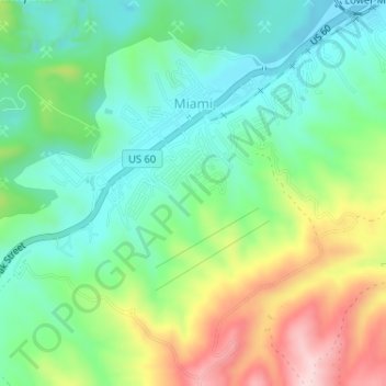
Name: Miami topographic map, elevation, terrain.
Location: Miami, Gila County, Arizona, 85539, United States (33.38158 -110.89178 33.40476 -110.85971)
Average elevation: 3,678 ft
Minimum elevation: 3,363 ft
Maximum elevation: 4,275 ft
Gila County trails, hiking, mountain biking, running and outdoor activities
Other topographic maps
Click on a map to view its topography, its elevation and its terrain.
Pine
United States > Arizona > Gila County > Pine
Pine and the adjacent community of Strawberry are rapidly growing vacation and retirement centers in north-central Arizona, below the Mogollon Rim. Pine's elevation is 5,448 feet (1,661 m), and the Pine post office was established in 1884.
Average elevation: 5,886 ft
Globe
United States > Arizona > Gila County > Globe
Globe has a semi-arid climate, characterized by hot summers and moderate to warm winters. Globe's arid climate is somewhat tempered by its elevation, however, leading to slightly cooler temperatures and slightly more precipitation than Phoenix or Yuma.
Average elevation: 3,776 ft