Geolocate

Gisela topographic map

Click on the map to display elevation.

About this map

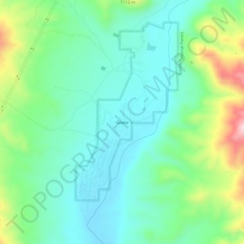
Name: Gisela topographic map, elevation, terrain.

Location: Gisela, Gila County, Arizona, United States (34.08171 -111.29986 34.12171 -111.25986)

Average elevation: 3,140 ft

Minimum elevation: 2,808 ft

Maximum elevation: 4,019 ft

Gila County trails, hiking, mountain biking, running and outdoor activities

Other topographic maps

Click on a map to view its topography, its elevation and its terrain.

Theodore Roosevelt Lake

United States > Arizona > Gila County

Average elevation: 2,972 ft

Pine

United States > Arizona > Gila County > Pine

Pine and the adjacent community of Strawberry are rapidly growing vacation and retirement centers in north-central Arizona, below the Mogollon Rim. Pine's elevation is 5,448 feet (1,661 m), and the Pine post office was established in 1884.

Average elevation: 5,886 ft

Star Valley

United States > Arizona > Gila County

According to the United States Census Bureau, the town has a total area of 36.1 square miles (93.6 km2), of which 0.01 square miles (0.02 km2), or 0.03%, is water. Star Valley sits at an elevation of 4,650 feet (1,420 m) and takes its name from the valley in which it is located, formed by Houston Creek, which…

Average elevation: 4,951 ft

Tonto National Monument

United States > Arizona > Gila County

Average elevation: 2,818 ft

Peridot

United States > Arizona > Gila County

Average elevation: 2,690 ft

Hayden

United States > Arizona > Gila County

Average elevation: 2,060 ft

Quartsite Tank

United States > Arizona > Gila County

Average elevation: 4,646 ft

Miami

United States > Arizona > Gila County

Average elevation: 3,678 ft

Rye Creek

United States > Arizona > Gila County

Average elevation: 3,586 ft

Walnut Canyon

United States > Arizona > Gila County

Average elevation: 4,262 ft

Payson town limits

United States > Arizona > Gila County

Average elevation: 4,993 ft

San Carlos

United States > Arizona > Gila County > San Carlos > Peridot

Average elevation: 2,822 ft

Gear up for your next adventure:

🔥Camping Stove - Portable stove for camping and backcountry cooking
🛡️Bear Spray Outdoor - Protection in bear country hikes
🧦Hiking Socks - Comfortable socks to prevent blisters on long hikes
🔋Solar Power Banks - Keep your GPS and phone charged in remote wilderness areas
Camping Coffee Makers - Enjoy premium coffee at the summit or campsite

As an Amazon Associate, this site earns from qualifying purchases at no extra cost to you.