
Copper Hill topographic map
Interactive map
Click on the map to display elevation.
About this map
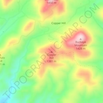
Name: Copper Hill topographic map, elevation, terrain.
Location: Copper Hill, Gila County, Arizona, 85501, United States (33.42278 -110.76683 33.42288 -110.76673)
Average elevation: 4,134 ft
Minimum elevation: 3,675 ft
Maximum elevation: 4,692 ft
Gila County trails, hiking, mountain biking, running and outdoor activities
Other topographic maps
Click on a map to view its topography, its elevation and its terrain.
Star Valley
United States > Arizona > Gila County
According to the United States Census Bureau, the town has a total area of 36.1 square miles (93.6 km2), of which 0.01 square miles (0.02 km2), or 0.03%, is water. Star Valley sits at an elevation of 4,650 feet (1,420 m) and takes its name from the valley in which it is located, formed by Houston Creek, which…
Average elevation: 4,951 ft
Pine
United States > Arizona > Gila County > Pine
Pine and the adjacent community of Strawberry are rapidly growing vacation and retirement centers in north-central Arizona, below the Mogollon Rim. Pine's elevation is 5,448 feet (1,661 m), and the Pine post office was established in 1884.
Average elevation: 5,886 ft