Geolocate

Peridot topographic map

Click on the map to display elevation.

👉 Easily get elevation data in JSON, GeoTIFF and KML formats using Elevation API
Thank you for supporting this site ❤️
Make a donation

About this map

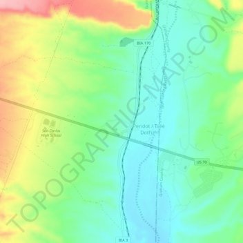
Name: Peridot topographic map, elevation, terrain.

Location: Peridot, Gila County, Arizona, 85542, United States (33.27844 -110.48169 33.32390 -110.43040)

Average elevation: 2,690 ft

Minimum elevation: 2,526 ft

Maximum elevation: 3,002 ft

Gila County trails, hiking, mountain biking, running and outdoor activities

Other topographic maps

Click on a map to view its topography, its elevation and its terrain.

Christopher Creek

United States > Arizona > Gila County

Average elevation: 6,073 ft

Rye

United States > Arizona > Gila County

Average elevation: 3,307 ft

Theodore Roosevelt Lake

United States > Arizona > Gila County

Average elevation: 2,972 ft

Strawberry

United States > Arizona > Gila County

Average elevation: 6,198 ft

Hayden

United States > Arizona > Gila County

Average elevation: 2,060 ft

Hardscrabble Mesa

United States > Arizona > Gila County

Average elevation: 5,807 ft

Globe

United States > Arizona > Gila County > Globe

Globe has a semi-arid climate, characterized by hot summers and moderate to warm winters. Globe's arid climate is somewhat tempered by its elevation, however, leading to slightly cooler temperatures and slightly more precipitation than Phoenix or Yuma.

Average elevation: 3,776 ft

Geronimo Estates

United States > Arizona > Gila County

Average elevation: 5,427 ft

Gisela

United States > Arizona > Gila County

Average elevation: 3,140 ft

Punkin Center

United States > Arizona > Gila County

Average elevation: 2,434 ft

Tonto National Monument

United States > Arizona > Gila County

Average elevation: 2,818 ft

Jakes Corner

United States > Arizona > Gila County

Average elevation: 3,005 ft

See Canyon Summer Homes

United States > Arizona > Gila County

Average elevation: 6,299 ft

Polles Mesa

United States > Arizona > Gila County

Average elevation: 4,199 ft

Copper Hill

United States > Arizona > Gila County

Average elevation: 4,134 ft

Gear up for your next adventure:

🩳Quick‑Dry Hiking Shorts - Comfortable and quick‑dry shorts for summer hiking
🧦Hiking Socks - Comfortable socks to prevent blisters on long hikes
🦺Reflective Outdoor Gear - Safety gear for low‑light conditions
🦶Hiking Gaiters - Keep debris and water out of your boots
📚Navigation Handbooks - Master the art of reading topographic maps and using a compass

As an Amazon Associate, this site earns from qualifying purchases at no extra cost to you.