
Wenonah topographic map
Interactive map
Click on the map to display elevation.
About this map
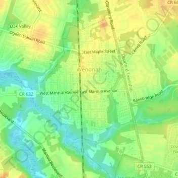
Name: Wenonah topographic map, elevation, terrain.
Location: Wenonah, Gloucester County, New Jersey, 08090, United States (39.78073 -75.16040 39.80262 -75.13810)
Average elevation: 59 ft
Minimum elevation: 0 ft
Maximum elevation: 108 ft
Gloucester County trails, hiking, mountain biking, running and outdoor activities
Other topographic maps
Click on a map to view its topography, its elevation and its terrain.
Mickleton
United States > New Jersey > Gloucester County > East Greenwich Township
Average elevation: 59 ft
Franklinville
United States > New Jersey > Gloucester County > Franklin Township
Average elevation: 105 ft
Mantua Creek
United States > New Jersey > Gloucester County > West Deptford Township
Average elevation: 43 ft
Buckingham Village
United States > New Jersey > Gloucester County > Mantua Township
Average elevation: 79 ft
Clarksboro
United States > New Jersey > Gloucester County > East Greenwich Township
Average elevation: 46 ft
Verga
United States > New Jersey > Gloucester County > West Deptford Township
Average elevation: 23 ft
Monroe Township
United States > New Jersey > Gloucester County > Monroe Township
Average elevation: 125 ft
Westcotville
United States > New Jersey > Gloucester County > Deptford Township
Average elevation: 52 ft
Williamstown
United States > New Jersey > Gloucester County > Monroe Township
Average elevation: 144 ft
Hurffville
United States > New Jersey > Gloucester County > Washington Township > Hurffville
Average elevation: 85 ft
Sunset Beach
United States > New Jersey > Gloucester County > Deptford > Sunset Beach
Average elevation: 56 ft
Bridgeport
United States > New Jersey > Gloucester County > Logan Township > Bridgeport
Average elevation: 13 ft