
Shire Of Shark Bay topographic map
Interactive map
Click on the map to display elevation.
About this map
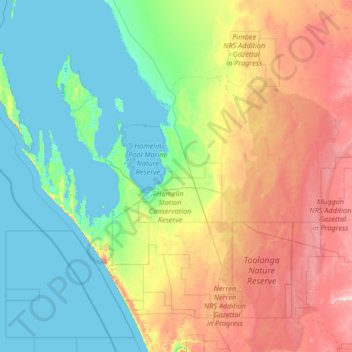
Name: Shire Of Shark Bay topographic map, elevation, terrain.
Location: Shire Of Shark Bay, Western Australia, 6537, Australia (-27.29793 112.86567 -25.35631 115.51578)
Average elevation: 328 ft
Minimum elevation: -3 ft
Maximum elevation: 1,371 ft
Other topographic maps
Click on a map to view its topography, its elevation and its terrain.
Gibson Desert
The Gibson Desert is located between the saline Kumpupintil Lake and Lake Macdonald along the Tropic of Capricorn, south of the Great Sandy Desert, east of the Little Sandy Desert, and north of the Great Victoria Desert. The altitude rises to just above 500 metres (1,600 ft) in places. As noted by early…
Average elevation: 1,522 ft
Perth
Australia > Western Australia > City of Perth
Perth, the capital of Western Australia, is situated on the Swan Coastal Plain, a flat expanse of sandy soil nestled between the Indian Ocean to the west and the Darling Scarp to the east. The Darling Scarp, also known as the Darling Range, is a low escarpment that extends north–south, marking a distinct…
Average elevation: 85 ft