
Königswinter topographic map
Interactive map
Click on the map to display elevation.
About this map
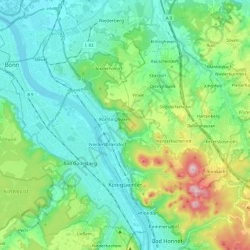
Name: Königswinter topographic map, elevation, terrain.
Average elevation: 449 ft
Minimum elevation: 141 ft
Maximum elevation: 1,421 ft
Other topographic maps
Click on a map to view its topography, its elevation and its terrain.
Heisterbacherrott
Germany > North Rhine-Westphalia > Rhein-Sieg-Kreis > Königswinter
Average elevation: 692 ft
Niederhalberg
Germany > North Rhine-Westphalia > Rhein-Sieg-Kreis > Hennef (Sieg) > Niederhalberg
Average elevation: 472 ft
Uthweiler
Germany > North Rhine-Westphalia > Rhein-Sieg-Kreis > Königswinter > Uthweiler
Average elevation: 515 ft