
Salta topographic map
Interactive map
Click on the map to display elevation.
Salta
Salta has a subtropical highland climate (Cwb, according to the Köppen climate classification), and it is characterized by pleasant weather year-round. Located in the subtropical north, but at an altitude of 1,200 metres, Salta enjoys 4 distinct seasons: summers are warm with frequent thunderstorms, with daytime highs around 26 to 28 °C (78.8 to 82.4 °F) and pleasant, refreshing nights around 15 or 16 °C (59 or 61 °F). Fall brings dry weather, pleasant days at around 22 °C (71.6 °F) and mild nights at around 10 °C (50.0 °F). By winter, the dryness is extreme, with very few rain episodes. Nights are cool at 3 °C (37.4 °F) on average, but daytime heating allows for high temperatures of 19 °C (66.2 °F). Snow is rare and frost is quite common, with temperatures reaching down to −7 °C (19.4 °F) during the coldest nights. Spring brings sunny weather with warm days and mild nights: days range from 25 to 28 °C (77.0 to 82.4 °F) with nights between 10 to 14 °C (50.0 to 57.2 °F). Salta's winters are rather warm for its elevation and far inland position for a location being just outside the tropics.
About this map
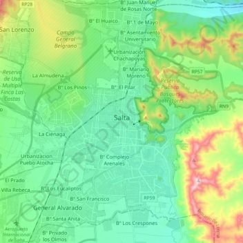
Name: Salta topographic map, elevation, terrain.
Location: Salta, Municipio de Salta, Capital, Salta, Argentina (-24.87349 -65.47912 -24.71081 -65.34063)
Average elevation: 4,167 ft
Minimum elevation: 3,609 ft
Maximum elevation: 5,781 ft
Other topographic maps
Click on a map to view its topography, its elevation and its terrain.
Colomé
Colomé is a village and rural municipality in Salta Province in northwestern Argentina. It is located about 20 km from Molinos, Salta. This settlement was established by the last Spanish governor of Salta, Nicolás Severo de Isasmendi, in 1831. His daughter Ascención imported grapevines from France and…
Average elevation: 7,520 ft
Nevado de Quehuar
Argentina > Salta > Municipio de San Antonio de los Cobres
Average elevation: 18,822 ft