Geolocate

Liège topographic map

Interactive map

Click on the map to display elevation.

About this map

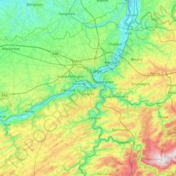
Name: Liège topographic map, elevation, terrain.

Location: Liège, Wallonia, Belgium (50.39548 5.34939 50.81212 5.81871)

Average elevation: 623 ft

Minimum elevation: 157 ft

Maximum elevation: 1,850 ft

Other topographic maps

Click on a map to view its topography, its elevation and its terrain.

Le Mayon

Belgium > Wallonia > Gouvy

Average elevation: 1,519 ft

Russai

Belgium > Wallonia > Lierneux

Average elevation: 1,168 ft

Han

Belgium > Wallonia > Tintigny > Han

Average elevation: 1,119 ft

Petit-Rechain

Belgium > Wallonia > Verviers > Petit-Rechain

Average elevation: 840 ft

Wardin

Belgium > Wallonia > Bastogne > Wardin

Average elevation: 1,575 ft

Barbençon

Belgium > Wallonia > Beaumont > Barbençon

Average elevation: 738 ft

Hennuyères

Belgium > Wallonia > Braine-Le-Comte > Hennuyères

Average elevation: 328 ft