Geolocate

Tomball topographic map

Interactive map

Click on the map to display elevation.

Tomball

Settlement began in the Tomball area in the early 19th century, where settlers found an open, fertile land that received adequate rainfall—perfect conditions for farming and raising cattle. It was on a land granted in 1838 to William Hurd's heirs. In 1906 the area began to boom. Railroad line engineers often noticed that the Tomball area was on the boundary between the low hills of Texas and the flat coastal plains of the Gulf, making it an ideal location for a train stop. The railroad could load more cargo on each car, because the topography gently sloped toward the Galveston ports and provided an easier downhill coast. Thomas Henry Ball, an attorney for the Trinity and Brazos Valley Railroad, convinced the railroad to run the line right through downtown Tomball. Soon after, people came in droves to this new train stop. Hotels, boarding houses, saloons, and mercantile stores all began to spring up in the area. At first, people called the area Peck, after a chief civil engineer of the railroad line. However, on December 2, 1907, the town was officially named Tom Ball, later to be shortened to one word, for Mr. Ball.

Wikipedia (CC-BY-SA 3.0)

About this map

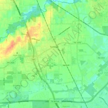
Name: Tomball topographic map, elevation, terrain.

Location: Tomball, Harris County, Texas, United States (30.04622 -95.66653 30.13599 -95.58413)

Average elevation: 171 ft

Minimum elevation: 121 ft

Maximum elevation: 253 ft

Harris County trails, hiking, mountain biking, running and outdoor activities

Other topographic maps

Click on a map to view its topography, its elevation and its terrain.

Cypress

United States > Texas > Harris County

Average elevation: 151 ft

Spring

United States > Texas > Harris County

Average elevation: 115 ft

Cedar Bayou

United States > Texas > Harris County > Baytown

Average elevation: 30 ft

Spring

United States > Texas > Harris County

Average elevation: 115 ft

Atascocita

United States > Texas > Harris County

Average elevation: 62 ft

Memorial Park

United States > Texas > Harris County > Houston

Average elevation: 69 ft

Hockley

United States > Texas > Harris County

Average elevation: 223 ft

Black Cat Ridge

United States > Texas > Harris County > Houston

Average elevation: 79 ft

Pelly

United States > Texas > Harris County > Baytown

Average elevation: 26 ft

Tuffly Park

United States > Texas > Harris County > Houston

Average elevation: 52 ft

Hockley Mound

United States > Texas > Harris County

Average elevation: 213 ft

Bayside Terrace

United States > Texas > Harris County > La Porte

Average elevation: 13 ft

Kingwood

United States > Texas > Harris County > Houston

Average elevation: 72 ft

Crosby

United States > Texas > Harris County

Average elevation: 49 ft

Kings Point

United States > Texas > Harris County > Houston

Average elevation: 66 ft

Fairfield

United States > Texas > Harris County

Average elevation: 184 ft

Forest Cove

United States > Texas > Harris County > Houston

Average elevation: 79 ft

Cypress

United States > Texas > Harris County

Average elevation: 151 ft

East Houston

United States > Texas > Harris County > Houston

Average elevation: 49 ft

Seabrook

United States > Texas > Harris County > Seabrook > Seabrook

Average elevation: 10 ft

Fall Creek

United States > Texas > Harris County

Average elevation: 62 ft

Channelview

United States > Texas > Harris County

Average elevation: 23 ft

Klein

United States > Texas > Harris County

Average elevation: 141 ft

Yellowstone Park

United States > Texas > Harris County > Houston

Average elevation: 49 ft

Huffman

United States > Texas > Harris County

Average elevation: 72 ft

Addicks

United States > Texas > Harris County > Houston > Addicks

Average elevation: 92 ft

Yellowstone Park

United States > Texas > Harris County > Houston

Average elevation: 49 ft

Harrisburg

United States > Texas > Harris County > Houston > Harrisburg

Average elevation: 33 ft

Golden Acres

United States > Texas > Harris County > Pasadena

Average elevation: 36 ft