
Chesterfield topographic map
Interactive map
Click on the map to display elevation.
About this map
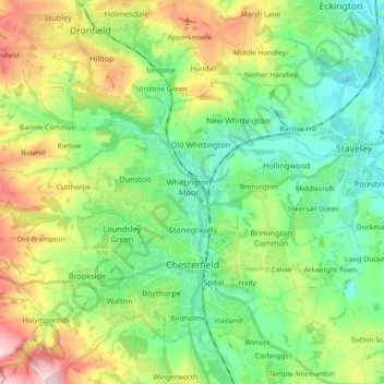
Name: Chesterfield topographic map, elevation, terrain.
Average elevation: 417 ft
Minimum elevation: 135 ft
Maximum elevation: 1,001 ft
Other topographic maps
Click on a map to view its topography, its elevation and its terrain.
Birch Vale
United Kingdom > England > Derbyshire > High Peak > New Mills > Hayfield
Average elevation: 823 ft
Alfreton Park
United Kingdom > England > Derbyshire > Amber Valley > Alfreton CP > Oakerthorpe
Average elevation: 381 ft
Sawmills
United Kingdom > England > Derbyshire > Amber Valley > Ripley > Fritchley
Average elevation: 390 ft
Heanor
United Kingdom > England > Derbyshire > Amber Valley
Samuel Lewis's A Topographical Dictionary of England, published in 1848, states that Heanor parish "abounds with coal and ironstone, both worked extensively, the collieries alone affording employment to more than 2000 persons. The town is pleasantly situated upon an eminence, on the road from Derby to…
Average elevation: 335 ft