Geolocate

Riddings topographic map

Click on the map to display elevation.

About this map

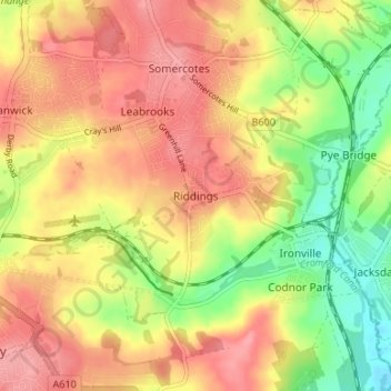
Name: Riddings topographic map, elevation, terrain.

Location: Riddings, Amber Valley, Derbyshire, East Midlands, England, DE55 4EG, United Kingdom (53.04739 -1.38724 53.08739 -1.34724)

Average elevation: 384 ft

Minimum elevation: 217 ft

Maximum elevation: 502 ft

Other topographic maps

Click on a map to view its topography, its elevation and its terrain.

Hazelwood CP

United Kingdom > England > Derbyshire > Amber Valley

Average elevation: 361 ft

Crich CP

United Kingdom > England > Derbyshire > Amber Valley

The memorial tower ('Crich Stand') was completed in 1923 as a memorial to the 11,409 soldiers from the Sherwood Foresters Regiment who died in World War I, a dedication that was later extended to include World War II. It was built on an limestone outcrop above the village, at an altitude of 1,000 feet (300 m)…

Average elevation: 522 ft

Swanwick CP

United Kingdom > England > Derbyshire > Amber Valley

Average elevation: 410 ft

Ripley

United Kingdom > England > Derbyshire > Amber Valley > Waingroves

Average elevation: 384 ft

Alfreton CP

United Kingdom > England > Derbyshire > Amber Valley

Average elevation: 374 ft

Denby CP

United Kingdom > England > Derbyshire > Amber Valley

Average elevation: 374 ft

Gear up for your next adventure:

📷Action Camera - Capture your outdoor adventures in HD
😴Insulated Sleeping Pads - Compact and warm pads for high-elevation camping
🥩Freeze-Dried Meals - Nutritious and lightweight food for remote expeditions
🌲Outdoor Survival Books - Best books on survival skills
🎒Hydration Pack - Hands‑free water reservoir for long hikes

As an Amazon Associate, this site earns from qualifying purchases at no extra cost to you.