
Schnecksville topographic map
Interactive map
Click on the map to display elevation.
Schnecksville
According to the U.S. Census Bureau, Schnecksville has a total area of 2.7 square miles (7.0 km2), of which 0.01 square miles (0.02 km2), or 0.28%, are water. Schnecksville sits on a ridge at an elevation of about 660 feet (200 m) above sea level. To the west, water flows to Jordan Creek, while to the east water flows to Coplay Creek. Both creeks are southeast-flowing tributaries of the Lehigh River and part of the Delaware River watershed.
About this map
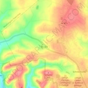
Name: Schnecksville topographic map, elevation, terrain.
Average elevation: 646 ft
Minimum elevation: 472 ft
Maximum elevation: 751 ft
Lehigh County trails, hiking, mountain biking, running and outdoor activities
Other topographic maps
Click on a map to view its topography, its elevation and its terrain.
Orefield
United States > Pennsylvania > Lehigh County > North Whitehall Township
Average elevation: 463 ft
Ormrod
United States > Pennsylvania > Lehigh County > North Whitehall Township
Average elevation: 486 ft