
Brigham City topographic map
Interactive map
Click on the map to display elevation.
Brigham City
According to the United States Census Bureau, the city has a total area of 24.2 square miles (62.6 km2), of which 23.8 square miles (61.7 km2) is land and 0.35 square miles (0.9 km2), or 1.40%, is water. It lies at an elevation of 4,315 feet (1,315 m).
About this map
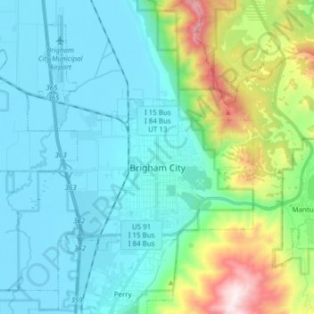
Name: Brigham City topographic map, elevation, terrain.
Location: Brigham City, Box Elder County, Utah, United States (41.46624 -112.12151 41.56309 -111.96877)
Average elevation: 5,016 ft
Minimum elevation: 4,206 ft
Maximum elevation: 8,189 ft
Box Elder County trails, hiking, mountain biking, running and outdoor activities
Other topographic maps
Click on a map to view its topography, its elevation and its terrain.