
Yachats topographic map
Interactive map
Click on the map to display elevation.
About this map
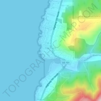
Name: Yachats topographic map, elevation, terrain.
Location: Yachats, Lincoln County, Oregon, United States (44.29894 -124.11090 44.32531 -124.09098)
Average elevation: 174 ft
Minimum elevation: -20 ft
Maximum elevation: 1,119 ft
Lincoln County trails, hiking, mountain biking, running and outdoor activities
Other topographic maps
Click on a map to view its topography, its elevation and its terrain.
Seal Rock State Recreation Site
United States > Oregon > Lincoln County > Seal Rock
Average elevation: 52 ft