
Cascade Locks topographic map
Interactive map
Click on the map to display elevation.
About this map
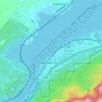
Name: Cascade Locks topographic map, elevation, terrain.
Location: Cascade Locks, Hood River County, Oregon, United States (45.65829 -121.90445 45.69097 -121.84013)
Average elevation: 331 ft
Minimum elevation: 59 ft
Maximum elevation: 2,300 ft
Hood River County trails, hiking, mountain biking, running and outdoor activities
Other topographic maps
Click on a map to view its topography, its elevation and its terrain.
Mount Hood
United States > Oregon > Hood River County
Timberline Lodge is a National Historic Landmark located on the southern flank of Mount Hood just below Palmer Glacier, with an elevation of about 6,000 ft (1,800 m).
Average elevation: 8,911 ft
Mount Hood
United States > Oregon > Hood River County
Timberline Lodge is a National Historic Landmark located on the southern flank of Mount Hood just below Palmer Glacier, with an elevation of about 6,000 ft (1,800 m).
Average elevation: 8,911 ft