
Make a donation
Gear up for your next adventure:
As an Amazon Associate, this site earns from qualifying purchases at no extra cost to you.
Bernardsville topographic map
Click on the map to display elevation.
Make a donation
Gear up for your next adventure:
As an Amazon Associate, this site earns from qualifying purchases at no extra cost to you.
Bernardsville
Bernardsville has a climate that borders between Humid continental and Humid subtropical with cool sometimes cold winters and warm to hot, humid summers on average. High elevations of the town have a warm summer humid continental climate with more snow during the winter and more orographic precipitation. Summer is the wettest season with frequent afternoon thunderstorms while Winter is the driest season.
Make a donation
Gear up for your next adventure:
As an Amazon Associate, this site earns from qualifying purchases at no extra cost to you.
About this map
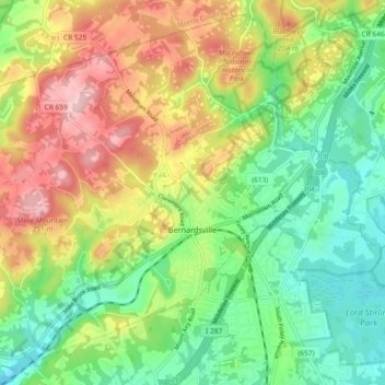
Name: Bernardsville topographic map, elevation, terrain.
Location: Bernardsville, Somerset County, New Jersey, United States (40.69287 -74.64098 40.75800 -74.54875)
Average elevation: 466 ft
Minimum elevation: 190 ft
Maximum elevation: 863 ft
Somerset County trails, hiking, mountain biking, running and outdoor activities
Make a donation
Gear up for your next adventure:
As an Amazon Associate, this site earns from qualifying purchases at no extra cost to you.
Other topographic maps
Click on a map to view its topography, its elevation and its terrain.
Basking Ridge
United States > New Jersey > Somerset County > Bernards Township
Average elevation: 322 ft
Rock Mill
United States > New Jersey > Somerset County > Montgomery Township
Average elevation: 410 ft
Make a donation
Gear up for your next adventure:
As an Amazon Associate, this site earns from qualifying purchases at no extra cost to you.
Neshanic
United States > New Jersey > Somerset County > Hillsborough Township
Average elevation: 213 ft
Make a donation
Gear up for your next adventure:
As an Amazon Associate, this site earns from qualifying purchases at no extra cost to you.
Make a donation
Gear up for your next adventure:
As an Amazon Associate, this site earns from qualifying purchases at no extra cost to you.
Chimney Rock
United States > New Jersey > Somerset County > Bridgewater Township
Average elevation: 184 ft
Blaziers Corner
United States > New Jersey > Somerset County > Bernardsville
Average elevation: 404 ft
Make a donation
Gear up for your next adventure:
As an Amazon Associate, this site earns from qualifying purchases at no extra cost to you.
Make a donation
Gear up for your next adventure:
As an Amazon Associate, this site earns from qualifying purchases at no extra cost to you.
Basking Ridge
United States > New Jersey > Somerset County > Bernards Township
Average elevation: 322 ft
Make a donation
Gear up for your next adventure:
As an Amazon Associate, this site earns from qualifying purchases at no extra cost to you.
North Branch Depot
United States > New Jersey > Somerset County > North Branch Depot
Average elevation: 125 ft
Lamington
United States > New Jersey > Somerset County > Bedminster Township
Average elevation: 177 ft
Make a donation
Gear up for your next adventure:
As an Amazon Associate, this site earns from qualifying purchases at no extra cost to you.
Liberty Corner
United States > New Jersey > Somerset County > Bernards Township > Liberty Corner
Average elevation: 279 ft
Woods Tavern
United States > New Jersey > Somerset County > Hillsborough Township
Average elevation: 92 ft
Make a donation
Gear up for your next adventure:
As an Amazon Associate, this site earns from qualifying purchases at no extra cost to you.
Green Knoll
United States > New Jersey > Somerset County > Bridgewater Township
Average elevation: 207 ft
Make a donation
Gear up for your next adventure:
As an Amazon Associate, this site earns from qualifying purchases at no extra cost to you.