
Make a donation
Gear up for your next adventure:
As an Amazon Associate, this site earns from qualifying purchases at no extra cost to you.
Sunriver topographic map
Click on the map to display elevation.
Make a donation
Gear up for your next adventure:
As an Amazon Associate, this site earns from qualifying purchases at no extra cost to you.
About this map
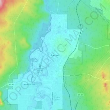
Name: Sunriver topographic map, elevation, terrain.
Location: Sunriver, Deschutes County, Oregon, 97707, United States (43.84400 -121.47852 43.92400 -121.39852)
Average elevation: 4,304 ft
Minimum elevation: 4,137 ft
Maximum elevation: 4,934 ft
Deschutes County trails, hiking, mountain biking, running and outdoor activities
Make a donation
Gear up for your next adventure:
As an Amazon Associate, this site earns from qualifying purchases at no extra cost to you.
Other topographic maps
Click on a map to view its topography, its elevation and its terrain.
Bend
United States > Oregon > Deschutes County
Bend is characterized by its distinctive topography, situated at an elevation of approximately 3,623 feet (1,105 meters) above sea level. The city lies within the high desert region of Central Oregon, bordered by the Cascade Mountains to the west, which provide a dramatic backdrop with peaks like the Three…
Average elevation: 3,678 ft
Redmond
United States > Oregon > Deschutes County
The city encompasses 15.5 square miles (40 km2) and is on a plateau, at an elevation of 3,077 feet (938 m). Redmond is 15 miles (24 km) north of Bend—the county seat of Deschutes County—144 miles (232 km) from Portland, 129 miles (208 km) from Salem—the capital of Oregon—and 126 miles (203 km) from Eugene.
Average elevation: 3,028 ft
Make a donation
Gear up for your next adventure:
As an Amazon Associate, this site earns from qualifying purchases at no extra cost to you.
Bend
United States > Oregon > Deschutes County
The Deschutes River runs through Bend, where it is dammed to form Mirror Pond. Bend's elevation is 3,623 feet (1,104 metres) above sea level.
Average elevation: 3,678 ft
Bend
United States > Oregon > Deschutes County
The Deschutes River runs through Bend, where it is dammed to form Mirror Pond. Bend's elevation is 3,623 feet (1,104 metres) above sea level.
Average elevation: 3,678 ft
Bend
United States > Oregon > Deschutes County
The Deschutes River runs through Bend, where it is dammed to form Mirror Pond. Bend's elevation is 3,623 feet (1,104 metres) above sea level.
Average elevation: 3,678 ft
Bend
United States > Oregon > Deschutes County
The Deschutes River runs through Bend, where it is dammed to form Mirror Pond. Bend's elevation is 3,623 feet (1,104 metres) above sea level. The city has a total area of 33.27 square miles (86.17 square kilometres), of which 33.01 sq mi (85.50 km2) is land and 0.26 sq mi (0.67 km2) is water.
Average elevation: 3,678 ft
Make a donation
Gear up for your next adventure:
As an Amazon Associate, this site earns from qualifying purchases at no extra cost to you.
Redmond
United States > Oregon > Deschutes County > Redmond
The city encompasses 15.5 square miles (40 km2) and is on a plateau, at an elevation of 3,077 feet (938 m). Redmond is 15 miles (24 km) north of Bend—the county seat of Deschutes County—144 miles (232 km) from Portland, 129 miles (208 km) from Salem—the capital of Oregon—and 126 miles (203 km) from Eugene.
Average elevation: 3,022 ft