
West Milford topographic map
Interactive map
Click on the map to display elevation.
About this map
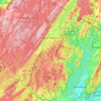
Name: West Milford topographic map, elevation, terrain.
Location: West Milford, Passaic County, New Jersey, United States (41.01098 -74.50321 41.20329 -74.27968)
Average elevation: 860 ft
Minimum elevation: 197 ft
Maximum elevation: 1,486 ft
Passaic County trails, hiking, mountain biking, running and outdoor activities
Other topographic maps
Click on a map to view its topography, its elevation and its terrain.
Bearfort Mountain
United States > New Jersey > Passaic County > West Milford
At an elevation of 1,331 feet (406 m) the ridge is the site of a 68 feet (21 m) high fire lookout tower built by the New Jersey Forest Fire Service.
Average elevation: 1,161 ft
Cupsaw Lake
United States > New Jersey > Passaic County > Ringwood > Erskine Lakes
Average elevation: 515 ft
Upper Greenwood Lake
United States > New Jersey > Passaic County > West Milford
Average elevation: 1,181 ft
Township of Wayne McCoog Park
United States > New Jersey > Passaic County > Wayne
Average elevation: 180 ft