
Monroeville topographic map
Interactive map
Click on the map to display elevation.
About this map
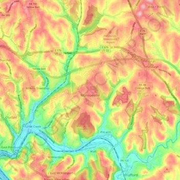
Name: Monroeville topographic map, elevation, terrain.
Average elevation: 1,060 ft
Minimum elevation: 722 ft
Maximum elevation: 1,345 ft
Allegheny County trails, hiking, mountain biking, running and outdoor activities
Other topographic maps
Click on a map to view its topography, its elevation and its terrain.
Allison Park
United States > Pennsylvania > Allegheny County > Hampton Township
Average elevation: 1,063 ft
Monroe Heights
United States > Pennsylvania > Allegheny County > Monroeville
Average elevation: 1,083 ft
Observatory Hill
United States > Pennsylvania > Allegheny County > Pittsburgh
Average elevation: 1,047 ft
Mustard
United States > Pennsylvania > Allegheny County > Elizabeth Township
Average elevation: 1,017 ft
Allegheny River Lock and Dam No. 2
United States > Pennsylvania > Allegheny County > O'Hara Township
Average elevation: 879 ft
Stoneybrooke Woods
United States > Pennsylvania > Allegheny County > Cheswick
Average elevation: 928 ft
Highland Park Reservoir No. 2
United States > Pennsylvania > Allegheny County > Pittsburgh
Average elevation: 902 ft
Lovedale
United States > Pennsylvania > Allegheny County > Elizabeth Township
Average elevation: 978 ft
Cochrans Mill
United States > Pennsylvania > Allegheny County > Jefferson Hills
Average elevation: 1,020 ft
Gibsonia
United States > Pennsylvania > Allegheny County > Richland Township
Average elevation: 1,142 ft
Neville Island
United States > Pennsylvania > Allegheny County > Neville Township
Average elevation: 948 ft
Dorseyville
United States > Pennsylvania > Allegheny County > Indiana Township
Average elevation: 1,066 ft
Glenwillard
United States > Pennsylvania > Allegheny County > Crescent Township > Glenwillard
Average elevation: 912 ft
Coverdale
United States > Pennsylvania > Allegheny County > Bethel Park > Coverdale
Average elevation: 1,161 ft
Bakerstown
United States > Pennsylvania > Allegheny County > Richland Township
Average elevation: 1,168 ft
Fairoaks
United States > Pennsylvania > Allegheny County > Leet Township > Fairoaks
Average elevation: 883 ft
Clinton
United States > Pennsylvania > Allegheny County > Findlay Township > Clinton
Average elevation: 1,148 ft
Carnot
United States > Pennsylvania > Allegheny County > Moon Township > Carnot
Average elevation: 1,102 ft