
Carolina Beach topographic map
Interactive map
Click on the map to display elevation.
Carolina Beach
Carolina Beach is characterized by its relatively flat topography, with elevations averaging around 13 feet above sea level. This coastal town is part of Pleasure Island and features a blend of sandy beaches and salt marshes. The surrounding area includes Carolina Beach State Park, which hosts diverse ecosystems including wetlands, maritime forests, and a unique Pocosin habitat that supports rare carnivorous plant species like Venus flytraps and pitcher plants. The terrain transitions from the beach, which provides expansive ocean views and recreational areas, to the inland regions where hiking trails meander through the park's natural landscapes. The proximity to the Cape Fear River adds to the ecological richness, creating a dynamic environment ideal for both residents and visitors.
About this map
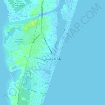
Name: Carolina Beach topographic map, elevation, terrain.
Average elevation: 7 ft
Minimum elevation: -7 ft
Maximum elevation: 43 ft
New Hanover County trails, hiking, mountain biking, running and outdoor activities
Other topographic maps
Click on a map to view its topography, its elevation and its terrain.
Wilmington Beach
United States > North Carolina > New Hanover County > Carolina Beach
Average elevation: 7 ft
Wilmington Beach
United States > North Carolina > New Hanover County > Carolina Beach
Average elevation: 7 ft
Forest Hills
United States > North Carolina > New Hanover County > Wilmington
Average elevation: 36 ft
Bradley Creek Point
United States > North Carolina > New Hanover County > Wilmington
Average elevation: 10 ft
Wrightsville
United States > North Carolina > New Hanover County > Wilmington
Average elevation: 13 ft
Hanby Beach
United States > North Carolina > New Hanover County > Kure Beach > Hanby Beach
Average elevation: 3 ft