
White Haven topographic map
Interactive map
Click on the map to display elevation.
White Haven
White Haven is located at 41°3′34″N 75°46′34″W / 41.05944°N 75.77611°W / 41.05944; -75.77611 (41.059532, -75.776123). The borough is 17 miles (27 km) south of Wilkes-Barre, and 4 miles (6 km) west of the I-476 and I-80 interchange. According to the U.S. Census Bureau, the borough has a total area of 1.2 square miles (3.2 km2), of which 1.2 square miles (3.2 km2) is land and 0.04 square miles (0.1 km2), or 2.12%, is water. White Haven's elevation is 1,221 feet (372 m) above sea level.
About this map
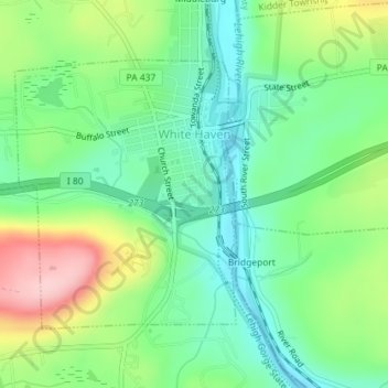
Name: White Haven topographic map, elevation, terrain.
Location: White Haven, Luzerne County, Pennsylvania, United States (41.04716 -75.79072 41.06562 -75.76989)
Average elevation: 1,283 ft
Minimum elevation: 1,063 ft
Maximum elevation: 1,703 ft
Luzerne County trails, hiking, mountain biking, running and outdoor activities
Other topographic maps
Click on a map to view its topography, its elevation and its terrain.
Glen Summit
United States > Pennsylvania > Luzerne County > Fairview Township
Average elevation: 1,768 ft
Roaring Brook
United States > Pennsylvania > Luzerne County > Hunlock Township
Average elevation: 1,106 ft
Springtown
United States > Pennsylvania > Luzerne County > Dorrance Township
Average elevation: 1,299 ft
Wapwallopen
United States > Pennsylvania > Luzerne County > Conyngham Township
Average elevation: 732 ft
Sweet Valley
United States > Pennsylvania > Luzerne County > Ross Township
Average elevation: 1,280 ft
Huntington Mills
United States > Pennsylvania > Luzerne County > Huntington Township
Average elevation: 948 ft
Hillside
United States > Pennsylvania > Luzerne County > Kingston Township
Average elevation: 1,122 ft
Shavertown
United States > Pennsylvania > Luzerne County > Kingston Township
Average elevation: 1,158 ft
Liewellyn Corners
United States > Pennsylvania > Luzerne County > Bear Creek Township
Average elevation: 1,473 ft
Hunlock Creek
United States > Pennsylvania > Luzerne County > Hunlock Township > Hunlock
Average elevation: 906 ft
Fern Glen
United States > Pennsylvania > Luzerne County > Black Creek Township
Average elevation: 1,283 ft
South Pond Dam
United States > Pennsylvania > Luzerne County > Hanover Township
Average elevation: 669 ft
Red Rock
United States > Pennsylvania > Luzerne County > Fairmount Township
Average elevation: 1,437 ft
Fern Glen
United States > Pennsylvania > Luzerne County > Black Creek Township
Average elevation: 1,283 ft
Carverton
United States > Pennsylvania > Luzerne County > Kingston Township
Average elevation: 1,191 ft