
Zachary topographic map
Interactive map
Click on the map to display elevation.
About this map
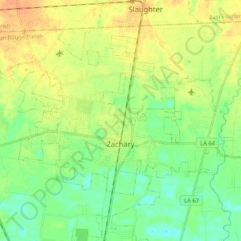
Name: Zachary topographic map, elevation, terrain.
Location: Zachary, East Baton Rouge Parish, Louisiana, United States (30.61149 -91.23277 30.70900 -91.08968)
Average elevation: 102 ft
Minimum elevation: 56 ft
Maximum elevation: 154 ft
East Baton Rouge Parish trails, hiking, mountain biking, running and outdoor activities
Other topographic maps
Click on a map to view its topography, its elevation and its terrain.
Evangeline Hermitage Estates
United States > Louisiana > East Baton Rouge Parish
Average elevation: 26 ft
Lake Sherwood Acres
United States > Louisiana > East Baton Rouge Parish > Baton Rouge
Average elevation: 46 ft
Marwede Place
United States > Louisiana > East Baton Rouge Parish > Baton Rouge
Average elevation: 56 ft
Liberty Farms
United States > Louisiana > East Baton Rouge Parish > Baton Rouge
Average elevation: 69 ft
South Baton Rouge
United States > Louisiana > East Baton Rouge Parish > Baton Rouge
Average elevation: 43 ft
Holiday Acres
United States > Louisiana > East Baton Rouge Parish > Baton Rouge
Average elevation: 72 ft
Prescott Place
United States > Louisiana > East Baton Rouge Parish > Baton Rouge
Average elevation: 66 ft
Sherwood Oaks
United States > Louisiana > East Baton Rouge Parish > Baton Rouge
Average elevation: 46 ft
Cunnard Place
United States > Louisiana > East Baton Rouge Parish > Baton Rouge
Average elevation: 72 ft
Monte Sano Trailer Park
United States > Louisiana > East Baton Rouge Parish > Baton Rouge
Average elevation: 69 ft
White Hills
United States > Louisiana > East Baton Rouge Parish > White Hills
Average elevation: 79 ft
Prescott Court
United States > Louisiana > East Baton Rouge Parish > Baton Rouge > Prescott Court
Average elevation: 66 ft
Moss Side Place
United States > Louisiana > East Baton Rouge Parish > Baton Rouge > Moss Side Place
Average elevation: 46 ft
Bernard Terrace
United States > Louisiana > East Baton Rouge Parish > Baton Rouge > Bernard Terrace
Average elevation: 62 ft
Jones Creek
United States > Louisiana > East Baton Rouge Parish > Jones Creek
Average elevation: 43 ft
Concord Park
United States > Louisiana > East Baton Rouge Parish > Baton Rouge > Concord Park
Average elevation: 49 ft
Hillside
United States > Louisiana > East Baton Rouge Parish > Baton Rouge > Hillside
Average elevation: 39 ft
Zachary
United States > Louisiana > East Baton Rouge Parish > Zachary > Zachary
Average elevation: 95 ft
Southmoor
United States > Louisiana > East Baton Rouge Parish > Baton Rouge > Southmoor
Average elevation: 52 ft