
Bear Mountain State Park topographic map
Interactive map
Click on the map to display elevation.
Bear Mountain State Park
There are over 50 official trails covering 235 miles (378 km), featuring a wide range of difficulties and elevation changes.
About this map
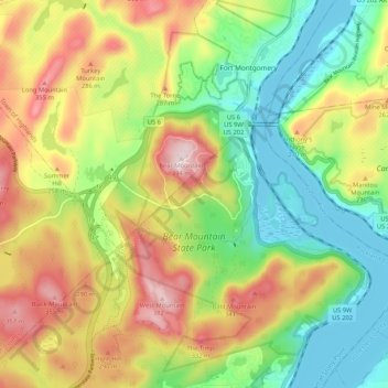
Name: Bear Mountain State Park topographic map, elevation, terrain.
Average elevation: 545 ft
Minimum elevation: 0 ft
Maximum elevation: 1,293 ft
Rockland County trails, hiking, mountain biking, running and outdoor activities
Other topographic maps
Click on a map to view its topography, its elevation and its terrain.
Tomkins Cove
United States > New York > Rockland County > Town of Stony Point
Average elevation: 223 ft