
Aurland topographic map
Interactive map
Click on the map to display elevation.
About this map
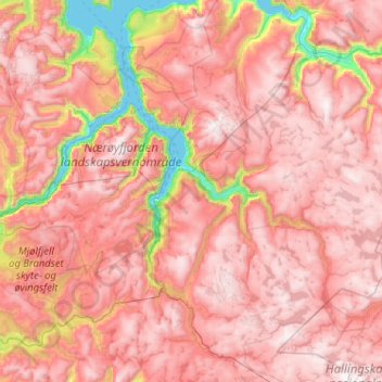
Name: Aurland topographic map, elevation, terrain.
Location: Aurland, Vestland, Norway (60.67555 6.72103 61.06635 7.75038)
Average elevation: 3,615 ft
Minimum elevation: 0 ft
Maximum elevation: 5,948 ft
Other topographic maps
Click on a map to view its topography, its elevation and its terrain.
Hornelen
The horizontal distance from the summit to the sea is approximately 500 metres (1,600 ft). Approximately 1 kilometre (0.62 mi) to the west of the cliffside is the highest point on the island Bremangerlandet, called Svartevassegga which has an elevation of 889 metres (2,917 ft). The rock in Hornelen consists of…
Average elevation: 925 ft