
Fairmount Township topographic map
Interactive map
Click on the map to display elevation.
About this map
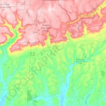
Name: Fairmount Township topographic map, elevation, terrain.
Average elevation: 1,555 ft
Minimum elevation: 778 ft
Maximum elevation: 2,461 ft
Luzerne County trails, hiking, mountain biking, running and outdoor activities
Other topographic maps
Click on a map to view its topography, its elevation and its terrain.
Glen Summit
United States > Pennsylvania > Luzerne County > Fairview Township
Average elevation: 1,768 ft
Roaring Brook
United States > Pennsylvania > Luzerne County > Hunlock Township
Average elevation: 1,106 ft
Springtown
United States > Pennsylvania > Luzerne County > Dorrance Township
Average elevation: 1,299 ft
Wapwallopen
United States > Pennsylvania > Luzerne County > Conyngham Township
Average elevation: 732 ft
Sweet Valley
United States > Pennsylvania > Luzerne County > Ross Township
Average elevation: 1,280 ft
Huntington Mills
United States > Pennsylvania > Luzerne County > Huntington Township
Average elevation: 948 ft
Hillside
United States > Pennsylvania > Luzerne County > Kingston Township
Average elevation: 1,122 ft
Shavertown
United States > Pennsylvania > Luzerne County > Kingston Township
Average elevation: 1,158 ft
Liewellyn Corners
United States > Pennsylvania > Luzerne County > Bear Creek Township
Average elevation: 1,473 ft
Hunlock Creek
United States > Pennsylvania > Luzerne County > Hunlock Township > Hunlock
Average elevation: 906 ft
Fern Glen
United States > Pennsylvania > Luzerne County > Black Creek Township
Average elevation: 1,283 ft
South Pond Dam
United States > Pennsylvania > Luzerne County > Hanover Township
Average elevation: 669 ft
Red Rock
United States > Pennsylvania > Luzerne County > Fairmount Township
Average elevation: 1,437 ft
Fern Glen
United States > Pennsylvania > Luzerne County > Black Creek Township
Average elevation: 1,283 ft
Carverton
United States > Pennsylvania > Luzerne County > Kingston Township
Average elevation: 1,191 ft