
Las Vegas topographic map
Interactive map
Click on the map to display elevation.
Las Vegas
Las Vegas is characterized by its distinctive topography, which features a mix of arid desert landscapes and mountainous terrain. The city itself sits at an elevation of approximately 2,030 feet (620 meters) above sea level, while the surrounding peaks reach heights exceeding 10,000 feet (3,000 meters), including the prominent Mount Charleston, which stands at 11,916 feet (3,632 meters). The area is framed by the Spring Mountains to the northwest and the Sierra Nevada to the west, creating a dramatic contrast between the valley floors and the towering mountain ridges. This unique elevation gradient contributes to the region's dry climate, as the mountains block moisture-laden winds from the Pacific, resulting in minimal rainfall and typical desert conditions. Additionally, features such as the Las Vegas Valley and Lake Mead further illustrate the diversity of the terrain, offering a blend of flatlands and elevated areas.
About this map
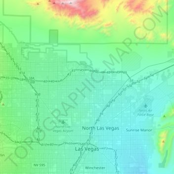
Name: Las Vegas topographic map, elevation, terrain.
Location: Las Vegas, Clark County, Nevada, United States (36.12955 -115.42428 36.38084 -115.06207)
Average elevation: 2,480 ft
Minimum elevation: 1,657 ft
Maximum elevation: 6,890 ft
Clark County trails, hiking, mountain biking, running and outdoor activities
Other topographic maps
Click on a map to view its topography, its elevation and its terrain.