
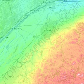
Saint Lawrence County topographic map
Interactive map
Click on the map to display elevation.
About this map
Name: Saint Lawrence County topographic map, elevation, terrain.
Location: Saint Lawrence County, New York, United States (44.05037 -75.86012 45.01586 -74.52519)
Average elevation: 784 ft
Minimum elevation: 144 ft
Maximum elevation: 3,048 ft
New York trails, hiking, mountain biking, running and outdoor activities
Other topographic maps
Click on a map to view its topography, its elevation and its terrain.
Central Park
United States > New York > New York County > New York
In June 1856, Fernando Wood appointed a "consulting board" of seven people, headed by author Washington Irving, to inspire public confidence in the proposed development. Wood hired military engineer Egbert Ludovicus Viele as the park's chief engineer, tasking him with a topographical survey of the site. The…
Average elevation: 85 ft
Mohegan Heights
United States > New York > Westchester County > City of Yonkers
Average elevation: 190 ft
Kaaterskill High Peak
United States > New York > Greene County > Town of Hunter
Average elevation: 2,789 ft
Harbor Hills Park
United States > New York > Nassau County > Village of Great Neck Estates
Average elevation: 33 ft
Cooper Lake
United States > New York > Ulster County > Town of Woodstock > Lake Hill
Average elevation: 1,204 ft
Cowdens Corner
United States > New York > Chautauqua County > Town of Arkwright
Average elevation: 1,276 ft
Woodcrest Bruderhof
United States > New York > Ulster County > Town of Esopus
Average elevation: 276 ft
Constantia Center
United States > New York > Oswego County > Town of Constantia
Average elevation: 554 ft
Dunham Hollow
United States > New York > Rensselaer County > Town of Nassau
Average elevation: 1,217 ft
South New Berlin
United States > New York > Chenango County > Town of New Berlin
Average elevation: 1,247 ft
Woodcock Mountain
United States > New York > Saratoga County > Town of Hadley
Average elevation: 889 ft
Ellenburg Mountain
United States > New York > Clinton County > Town of Ellenburg
Average elevation: 2,238 ft
Lake Katonah
United States > New York > Westchester County > Town of Lewisboro
Average elevation: 417 ft
Niagara Escarpment
United States > New York > Niagara County > City of Lockport
Average elevation: 489 ft
West Coxsackie
United States > New York > Greene County > Village of Coxsackie
Average elevation: 108 ft
Mount Marcy
United States > New York > Essex County > Town of Keene
Mount Marcy is the highest point in the Adirondack Mountains and the U.S. state of New York, with an elevation of 5,343.1 feet (1,628.6 m). It is located in the town of Keene in Essex County. The mountain is in the heart of the High Peaks Wilderness Area in Adirondack Park. Like the surrounding Adirondack…
Average elevation: 4,229 ft
West Genesee Terrace
United States > New York > Onondaga County > Fairmount > Town of Camillus
Average elevation: 548 ft
Ontario Pond
United States > New York > Niagara County > City of North Tonawanda
Average elevation: 581 ft
Hydepark Recreations
United States > New York > Dutchess County > Town of Hyde Park
Average elevation: 217 ft
Lake Vanare
United States > New York > Warren County > Town of Lake Luzerne
Average elevation: 1,014 ft
Diamond Point (hamlet)
United States > New York > Warren County > Town of Lake George
Average elevation: 627 ft
Oscawana Corners
United States > New York > Putnam County > Town of Putnam Valley
Average elevation: 518 ft
Toll Gate Corners
United States > New York > Cayuga County > Town of Moravia
Average elevation: 1,073 ft
Tuckers Corner
United States > New York > Ulster County > Town of Plattekill
Average elevation: 715 ft
South Ridge
United States > New York > Westchester County > Village of Rye Brook
Average elevation: 121 ft