Geolocate

Greeley topographic map

Click on the map to display elevation.

About this map

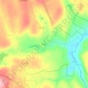
Name: Greeley topographic map, elevation, terrain.

Location: Greeley, Pike County, Pennsylvania, United States (41.40004 -75.01553 41.44004 -74.97553)

Average elevation: 1,184 ft

Minimum elevation: 896 ft

Maximum elevation: 1,457 ft

Pike County trails, hiking, mountain biking, running and outdoor activities

Other topographic maps

Click on a map to view its topography, its elevation and its terrain.

Palmyra Township

United States > Pennsylvania > Pike County

Average elevation: 1,447 ft

Greene Township

United States > Pennsylvania > Pike County

Average elevation: 1,614 ft

Gear up for your next adventure:

🦟Ultrasonic Repellers - Create a bug-free zone at your camp or rest stop
🧭Map Reading Tools - Tools and kits for map navigation
🪓Survival Multi‑Tool - Versatile tool for camp and trail tasks
😴Insulated Sleeping Pads - Compact and warm pads for high-elevation camping
📚USA Hiking Guide Books - Top trail guides and map books

As an Amazon Associate, this site earns from qualifying purchases at no extra cost to you.