
Make a donation
Gear up for your next adventure:
As an Amazon Associate, this site earns from qualifying purchases at no extra cost to you.
Westfall Township topographic map
Click on the map to display elevation.
Make a donation
Gear up for your next adventure:
As an Amazon Associate, this site earns from qualifying purchases at no extra cost to you.
About this map
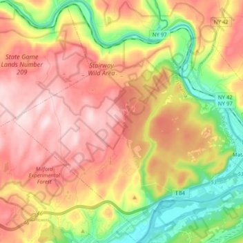
Name: Westfall Township topographic map, elevation, terrain.
Location: Westfall Township, Pike County, Pennsylvania, United States (41.32606 -74.85087 41.44290 -74.69473)
Average elevation: 942 ft
Minimum elevation: 361 ft
Maximum elevation: 1,467 ft
Pike County trails, hiking, mountain biking, running and outdoor activities
Make a donation
Gear up for your next adventure:
As an Amazon Associate, this site earns from qualifying purchases at no extra cost to you.
Other topographic maps
Click on a map to view its topography, its elevation and its terrain.
Hemlock Farms
United States > Pennsylvania > Pike County > Blooming Grove Township
Average elevation: 1,434 ft
Conashaugh Lakes
United States > Pennsylvania > Pike County > Dingman Township
Average elevation: 1,421 ft
Fawn Lake Forest
United States > Pennsylvania > Pike County > Lackawaxen Township
Average elevation: 1,247 ft
Make a donation
Gear up for your next adventure:
As an Amazon Associate, this site earns from qualifying purchases at no extra cost to you.
Sunrise Lake
United States > Pennsylvania > Pike County > Dingman Township
Average elevation: 1,365 ft
Tinkwig Dam
United States > Pennsylvania > Pike County > Lackawaxen Township
Average elevation: 1,201 ft
Make a donation
Gear up for your next adventure:
As an Amazon Associate, this site earns from qualifying purchases at no extra cost to you.
Gold Key Lake
United States > Pennsylvania > Pike County > Dingman Township
Average elevation: 1,316 ft
Make a donation
Gear up for your next adventure:
As an Amazon Associate, this site earns from qualifying purchases at no extra cost to you.
Craig's Crest
United States > Pennsylvania > Pike County > Delaware Township
Average elevation: 951 ft