
Make a donation
Gear up for your next adventure:
As an Amazon Associate, this site earns from qualifying purchases at no extra cost to you.
Ichtegem topographic map
Click on the map to display elevation.
Make a donation
Gear up for your next adventure:
As an Amazon Associate, this site earns from qualifying purchases at no extra cost to you.
Ichtegem
Ichtegem ligt in Zandig Vlaanderen (Westelijk Houtland) met een hoogte van 10 tot 20 meter. In het zuidoosten vindt men de steilrand naar het Plateau van Wijnendale, waar men ook het Wijnendalebos en Kasteel van Wijnendale vindt. Hier is 51 meter het hoogste punt, bij het gehucht De Reiger. Het plateau vormt een waterscheiding: beken ten zuiden hiervan lopen af in zuidelijke richting, naar de Handzamevaart. Beken ten noorden hiervan lopen in noordelijke richting naar de Moerdijkvaart.
Make a donation
Gear up for your next adventure:
As an Amazon Associate, this site earns from qualifying purchases at no extra cost to you.
About this map
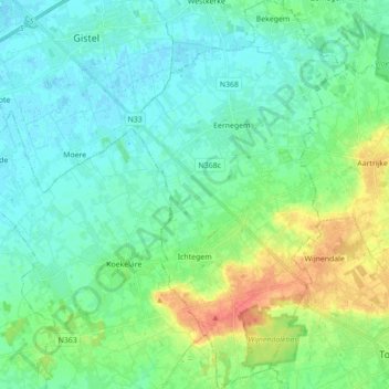
Name: Ichtegem topographic map, elevation, terrain.
Location: Ichtegem, Oostende, West-Vlaanderen, 8480, België (51.05487 2.98199 51.16475 3.07857)
Average elevation: 46 ft
Minimum elevation: -7 ft
Maximum elevation: 177 ft
Make a donation
Gear up for your next adventure:
As an Amazon Associate, this site earns from qualifying purchases at no extra cost to you.
Other topographic maps
Click on a map to view its topography, its elevation and its terrain.
Make a donation
Gear up for your next adventure:
As an Amazon Associate, this site earns from qualifying purchases at no extra cost to you.
Make a donation
Gear up for your next adventure:
As an Amazon Associate, this site earns from qualifying purchases at no extra cost to you.
Make a donation
Gear up for your next adventure:
As an Amazon Associate, this site earns from qualifying purchases at no extra cost to you.
De Meiboom
België > West-Vlaanderen > Oostende > Oudenburg > Roksem > De Meiboom
Average elevation: 20 ft