
Make a donation
Gear up for your next adventure:
As an Amazon Associate, this site earns from qualifying purchases at no extra cost to you.
Općina Ivanska topographic map
Click on the map to display elevation.
Make a donation
Gear up for your next adventure:
As an Amazon Associate, this site earns from qualifying purchases at no extra cost to you.
About this map
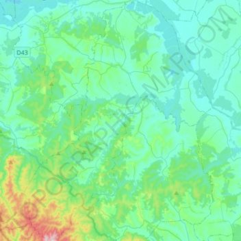
Name: Općina Ivanska topographic map, elevation, terrain.
Location: Općina Ivanska, Bjelovar-Bilogora County, 43231, Croatia (45.64254 16.69441 45.83518 16.91071)
Average elevation: 499 ft
Minimum elevation: 318 ft
Maximum elevation: 1,427 ft
Make a donation
Gear up for your next adventure:
As an Amazon Associate, this site earns from qualifying purchases at no extra cost to you.
Other topographic maps
Click on a map to view its topography, its elevation and its terrain.
Bjelovar
Croatia > Bjelovar-Bilogora County
The city of Bjelovar has an area of 181.75 km2 (70.2 sq mi), and administratively it includes 31 other areas. North-east of Bjelovar there is a long, low elevation called Bilogora, with an average height of 150–200 m (highest point: Rajčevica, 309 m). The geology of the area consists of Pliocene sandy marl…
Average elevation: 482 ft