
Make a donation
Gear up for your next adventure:
As an Amazon Associate, this site earns from qualifying purchases at no extra cost to you.
Oklahoma City topographic map
Click on the map to display elevation.
Make a donation
Gear up for your next adventure:
As an Amazon Associate, this site earns from qualifying purchases at no extra cost to you.
Oklahoma City
Oklahoma City is situated in a region characterized by diverse topography that reflects the broader geographical features of the state. The terrain predominantly consists of gently rolling plains, which gradually rise in elevation toward the west, where the land transitions into the rugged Arbuckle Mountains. This ancient mountain range, reaching heights of approximately 1,412 feet (431 meters) above sea level, is notable for its granite and limestone formations that date back billions of years. The city itself is positioned on the edge of a vast prairie landscape, interspersed with rivers, such as the North Canadian River, which flow through the area. The topography is shaped by its position in a climate zone that experiences significant temperature variations and seasonal weather patterns, including the potential for severe storms. Overall, Oklahoma City's terrain offers a mix of urban development and natural features that contribute to the region's unique ecological and geological identity.
Make a donation
Gear up for your next adventure:
As an Amazon Associate, this site earns from qualifying purchases at no extra cost to you.
About this map
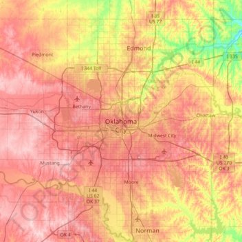
Name: Oklahoma City topographic map, elevation, terrain.
Location: Oklahoma City, Oklahoma County, Oklahoma, United States (35.29070 -97.83095 35.67487 -97.12472)
Average elevation: 1,188 ft
Minimum elevation: 883 ft
Maximum elevation: 1,424 ft
Oklahoma County trails, hiking, mountain biking, running and outdoor activities
Make a donation
Gear up for your next adventure:
As an Amazon Associate, this site earns from qualifying purchases at no extra cost to you.
Other topographic maps
Click on a map to view its topography, its elevation and its terrain.
Will Rogers Park
United States > Oklahoma > Oklahoma County > Oklahoma City
Average elevation: 1,247 ft
Newalla
United States > Oklahoma > Oklahoma County > Oklahoma City
Newalla, with a current elevation of 1,148 feet, is located within the Eastern bounds of Oklahoma County and appears on the Harrah, Oklahoma U.S. Geological Survey Map due to their proximity. Newalla is a geographic area which spans unincorporated Oklahoma County and unincorporated Cleveland County (also…
Average elevation: 1,125 ft
Make a donation
Gear up for your next adventure:
As an Amazon Associate, this site earns from qualifying purchases at no extra cost to you.
Lightning Creek Holding Pond B Dam
United States > Oklahoma > Oklahoma County > Oklahoma City
Average elevation: 1,266 ft
Make a donation
Gear up for your next adventure:
As an Amazon Associate, this site earns from qualifying purchases at no extra cost to you.