
Pontiac topographic map
Click on the map to display elevation.
About this map
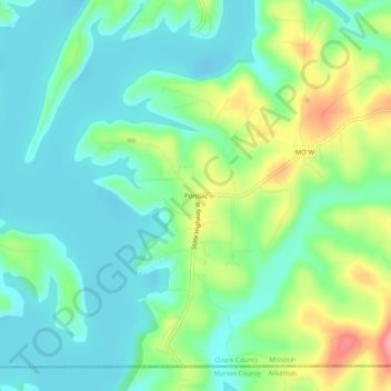
Name: Pontiac topographic map, elevation, terrain.
Location: Pontiac, Ozark County, Missouri, 65729, United States (36.49562 -92.62378 36.53562 -92.58378)
Average elevation: 735 ft
Minimum elevation: 633 ft
Maximum elevation: 971 ft
Ozark County trails, hiking, mountain biking, running and outdoor activities
Other topographic maps
Click on a map to view its topography, its elevation and its terrain.
Bull Shoals Lake
United States > Missouri > Ozark County > Theodosia
Bull Shoals Lake impounds the White River for the last time as water travels toward its mouth on the Mississippi River. Bull Shoals is thus the lake farthest downstream in a chain of four artificial lakes that include (from upstream to downstream) Beaver Lake, Table Rock Lake and Lake Taneycomo. The lake is…
Average elevation: 919 ft