
Make a donation
Gear up for your next adventure:
As an Amazon Associate, this site earns from qualifying purchases at no extra cost to you.
Yates Mountain topographic map
Click on the map to display elevation.
Make a donation
Gear up for your next adventure:
As an Amazon Associate, this site earns from qualifying purchases at no extra cost to you.
About this map
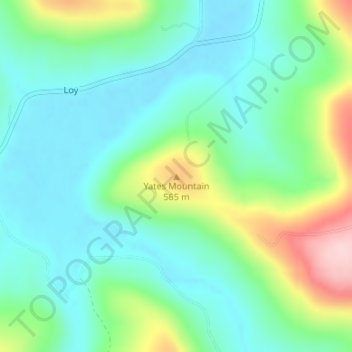
Name: Yates Mountain topographic map, elevation, terrain.
Average elevation: 1,562 ft
Minimum elevation: 1,348 ft
Maximum elevation: 2,116 ft
Make a donation
Gear up for your next adventure:
As an Amazon Associate, this site earns from qualifying purchases at no extra cost to you.
Other topographic maps
Click on a map to view its topography, its elevation and its terrain.
Make a donation
Gear up for your next adventure:
As an Amazon Associate, this site earns from qualifying purchases at no extra cost to you.
Saint Paul
United States > Arkansas > Madison County
St. Paul is located in the Upper Boston Mountains ecoregion. The ecoregion is generally higher and moister than the Lower Boston Mountains; elevations vary from 1,900 to 2,800 feet (580 to 850 m). Potential natural vegetation is oak–hickory forest. Characteristically, the forests of the Upper Boston…
Average elevation: 1,736 ft