Geolocate

Huntsville topographic map

Click on the map to display elevation.

About this map

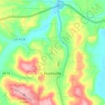
Name: Huntsville topographic map, elevation, terrain.

Location: Huntsville, Madison County, Arkansas, United States (36.07379 -93.76596 36.12348 -93.70290)

Average elevation: 1,450 ft

Minimum elevation: 1,247 ft

Maximum elevation: 1,752 ft

Madison County trails, hiking, mountain biking, running and outdoor activities

Other topographic maps

Click on a map to view its topography, its elevation and its terrain.

Alabam

United States > Arkansas > Madison County

Average elevation: 1,447 ft

Purdy

United States > Arkansas > Madison County

Average elevation: 1,476 ft

Marble

United States > Arkansas > Madison County

Average elevation: 1,401 ft

Georgetown

United States > Arkansas > Madison County

Average elevation: 1,568 ft

Venus

United States > Arkansas > Madison County

Average elevation: 1,995 ft

Yates Mountain

United States > Arkansas > Madison County

Average elevation: 1,562 ft

Alabam

United States > Arkansas > Madison County

Average elevation: 1,447 ft

Witter

United States > Arkansas > Madison County

Average elevation: 1,621 ft

Crosses

United States > Arkansas > Madison County

Average elevation: 1,608 ft

Forum

United States > Arkansas > Madison County

Average elevation: 1,490 ft

Patrick

United States > Arkansas > Madison County

Average elevation: 1,572 ft

Pettigrew

United States > Arkansas > Madison County

Average elevation: 2,073 ft

Pinnacle Mountain

United States > Arkansas > Madison County

Average elevation: 1,781 ft

Gear up for your next adventure:

🪵Folding Camp Saw - Compact saw for wood and campsite work
🪶Camping Sleeping Pad - Comfortable sleeping pad for backpacking
🪶Thermal Camp Blanket - Extra warmth for cold nights
🚁Photography Drones - Capture stunning aerial views of landforms and topography
👟Trail Running Shoes - Lightweight shoes for trail runners

As an Amazon Associate, this site earns from qualifying purchases at no extra cost to you.