Geolocate

Calauag topographic map

Click on the map to display elevation.

About this map

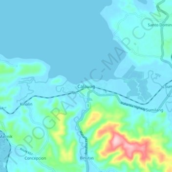
Name: Calauag topographic map, elevation, terrain.

Location: Calauag, Quezon, Calabarzon, 4318, Philippines (13.91721 122.24779 13.99721 122.32779)

Average elevation: 92 ft

Minimum elevation: -3 ft

Maximum elevation: 748 ft

Other topographic maps

Click on a map to view its topography, its elevation and its terrain.

Guinayangan

Philippines > Quezon

Average elevation: 223 ft

Talipan

Philippines > Quezon > Pagbilao

Average elevation: 184 ft

Tagkawayan

Philippines > Quezon

Average elevation: 351 ft

Alabat Island

Philippines > Quezon

Average elevation: 36 ft

Pagbilao Grande Island

Philippines > Quezon > Pagbilao

Average elevation: 43 ft

Dolores

Philippines > Quezon

Average elevation: 994 ft

Mauban

Philippines > Quezon

Average elevation: 515 ft

San Antonio

Philippines > Quezon

Average elevation: 463 ft

Dumacaa River

Philippines > Quezon > Lucena

Average elevation: 26 ft

Dalawang Islands

Philippines > Quezon > Polillo

Average elevation: 3 ft

Pulong Pasig Sandbar

Philippines > Quezon > Santo Angel

Average elevation: 0 ft

Malaking Tubig River

Philippines > Quezon > Lucena

Average elevation: 79 ft

Jomalig

Philippines > Quezon

Average elevation: 3 ft

Gear up for your next adventure:

🌧️Backpack Rain Cover - Keep gear dry in wet weather
📷Action Camera - Capture your outdoor adventures in HD
🧤Tactile Hiking Gloves - Keep hands warm while operating GPS and smartphone screens
🗻Climbing Gear Basics - Essential gear for beginner climbers
🔥Camping Stove - Portable stove for camping and backcountry cooking

As an Amazon Associate, this site earns from qualifying purchases at no extra cost to you.