
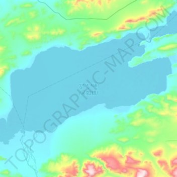
吴如错 topographic map
Interactive map
Click on the map to display elevation.
About this map
Name: 吴如错 topographic map, elevation, terrain.
Location: 吴如错, 申扎县, 那曲市, 西藏自治区, 中国 (31.61275 87.82750 31.80275 88.18000)
Average elevation: 15,318 ft
Minimum elevation: 14,928 ft
Maximum elevation: 17,835 ft
吴如错(藏語:འུར་རུ་མཚོ,威利转写:'ur ru mtsho,THL:Urru Tso)位于中国西藏自治区那曲市境内,地处尼玛县和申扎县交界处,湖面海拔4548米,面积342.7平方公里。属于色林错水系,上接孜桂错来水,下注恰规错。
Other topographic maps
Click on a map to view its topography, its elevation and its terrain.