
格仁错 topographic map
Interactive map
Click on the map to display elevation.
About this map
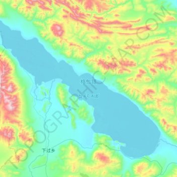
Name: 格仁错 topographic map, elevation, terrain.
Location: 格仁错, 申扎县, 那曲市, 西藏自治区, 中国 (30.95575 88.03904 31.31425 88.57025)
Average elevation: 16,188 ft
Minimum elevation: 15,243 ft
Maximum elevation: 19,780 ft
格仁错(藏語:སྐེ་རིང་མཚོ,威利转写:ske ring mtsho,THL:Kering Tso)位于西藏那曲市申扎县境内,地处申扎县西部,冈底斯山北麓,康巴多钦山南麓,湖面海拔4650米,面积475.9平方公里。湖泊形状呈东北-西南走向的长条状。湖水主要依靠东南岸入湖的申扎臧布和西南岸入湖的巴汝臧布补给,湖水经西北部的加虾臧布注入孜桂错。湖区属高寒草原半干旱气候,年均降水量200~300毫米左右,年均气温0℃。
Other topographic maps
Click on a map to view its topography, its elevation and its terrain.