Geolocate

Gela topographic map

Click on the map to display elevation.

About this map

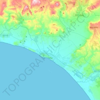
Name: Gela topographic map, elevation, terrain.

Location: Gela, Caltanissetta, Sicily, 93012, Italy (37.00208 14.11497 37.17205 14.44410)

Average elevation: 276 ft

Minimum elevation: 0 ft

Maximum elevation: 1,739 ft

Other topographic maps

Click on a map to view its topography, its elevation and its terrain.

Monte di Bubonia

Italy > Sicily > Caltanissetta > Mazzarino

Average elevation: 1,414 ft

Rocca di Aquilia

Italy > Sicily > Caltanissetta > Milena

Average elevation: 1,129 ft

Falconara

Italy > Sicily > Caltanissetta > Butera

Average elevation: 131 ft

Gear up for your next adventure:

🪶Multi‑Purpose Knife - Useful blade for camp and trail
🛠️Outdoor Gear Repair Kit - Essential tools to fix gear on the trail
🔦Compact Flashlight - Reliable flashlight for emergencies
Camping Coffee Makers - Enjoy premium coffee at the summit or campsite
🪶Compact Camp Shovel - Folding shovel for campsite tasks

As an Amazon Associate, this site earns from qualifying purchases at no extra cost to you.