Geolocate

Port-Cartier topographic map

Click on the map to display elevation.

About this map

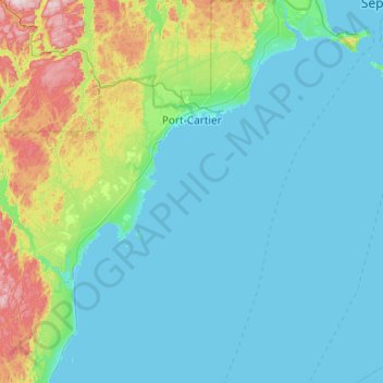
Name: Port-Cartier topographic map, elevation, terrain.

Location: Port-Cartier, Sept-Rivières, Côte-Nord, Quebec, Canada (49.58726 -67.48825 50.21210 -66.72403)

Average elevation: 253 ft

Minimum elevation: -13 ft

Maximum elevation: 1,768 ft

Other topographic maps

Click on a map to view its topography, its elevation and its terrain.

Sept-Îles

Canada > Quebec > Sept-Rivières > Sept-Îles

Average elevation: 213 ft

Lac de la Jeune Fille

Canada > Quebec > Sept-Rivières > Lac-Walker

Average elevation: 1,985 ft

Lac Mercier

Canada > Quebec > Sept-Rivières > Sept-Îles

Average elevation: 308 ft

Lac Louisa

Canada > Quebec > Sept-Rivières > Lac-Walker

Average elevation: 659 ft

Gear up for your next adventure:

🏕️Tent Footprint - Protect your tent base from wear
😴Insulated Sleeping Pads - Compact and warm pads for high-elevation camping
🔌USB Car Charger - Car charger for on‑the‑go power needs
📡GPS Antenna Upgrade - Enhance GPS reception in remote terrain
🪶Survival Guide Book - Expert advice for emergency preparedness

As an Amazon Associate, this site earns from qualifying purchases at no extra cost to you.