Geolocate

Lucena topographic map

Click on the map to display elevation.

About this map

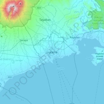
Name: Lucena topographic map, elevation, terrain.

Location: Lucena, Quezon, Calabarzon, 4301, Philippines (13.76604 121.45418 14.08604 121.77418)

Average elevation: 472 ft

Minimum elevation: -10 ft

Maximum elevation: 6,998 ft

Other topographic maps

Click on a map to view its topography, its elevation and its terrain.

Barangay 6

Philippines > Quezon > Lucena

Average elevation: 52 ft

Gear up for your next adventure:

🛶Inflatable Kayak - Portable kayak for rivers, lakes, and expeditions
🧢Sun Protection Hats - Wide-brimmed and UPF-rated hats for high-altitude sun safety
Camping Coffee Makers - Enjoy premium coffee at the summit or campsite
📻Weather Alert Radios - Stay informed of storm risks while off-the-grid
🗺️Topographic Maps - Detailed topo maps for hiking, exploring and outdoor navigation

As an Amazon Associate, this site earns from qualifying purchases at no extra cost to you.