Geolocate

Gratz topographic map

Click on the map to display elevation.

About this map

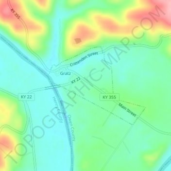
Name: Gratz topographic map, elevation, terrain.

Location: Gratz, Owen County, Kentucky, United States (38.46549 -84.95638 38.47790 -84.93656)

Average elevation: 568 ft

Minimum elevation: 433 ft

Maximum elevation: 837 ft

Owen County trails, hiking, mountain biking, running and outdoor activities

Other topographic maps

Click on a map to view its topography, its elevation and its terrain.

New Liberty

United States > Kentucky > Owen County

Average elevation: 830 ft

Perry Park

United States > Kentucky > Owen County

Average elevation: 568 ft

New Liberty

United States > Kentucky > Owen County

Average elevation: 830 ft

New

United States > Kentucky > Owen County

Average elevation: 797 ft

Gear up for your next adventure:

👖Convertible Hiking Pants - Versatile zip-off pants for changing altitudes and temperatures
🧥Men's Rain Shells - Premium waterproof and breathable jackets for mountain weather
🎒Trekking Poles - Sturdy poles for balance and stability on rough terrain
📷Action Cameras - Rugged cameras to document your journeys across rugged terrain
📡Handheld GPS Device - Reliable handheld GPS for outdoor navigation

As an Amazon Associate, this site earns from qualifying purchases at no extra cost to you.