Geolocate

Jonesboro topographic map

Click on the map to display elevation.

About this map

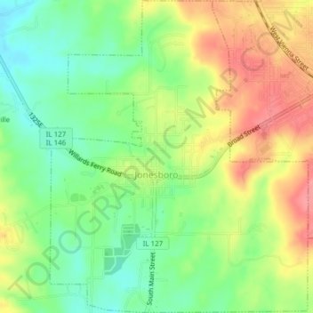
Name: Jonesboro topographic map, elevation, terrain.

Location: Jonesboro, Union County, Illinois, United States (37.43830 -89.28112 37.46850 -89.24967)

Average elevation: 548 ft

Minimum elevation: 420 ft

Maximum elevation: 696 ft

Union County trails, hiking, mountain biking, running and outdoor activities

Other topographic maps

Click on a map to view its topography, its elevation and its terrain.

Water Valley

United States > Illinois > Union County

Average elevation: 636 ft

Gear up for your next adventure:

🧭Pro Hiking Compasses - High-accuracy liquid-filled compasses for topographic orientation
💧Water Filtration Bottles - Safely drink from streams and lakes while exploring
🪶LED Camping Lantern - Bright lantern for camp lighting
🥾Women's Hiking Boots - Top-rated trail boots with ankle support and superior grip
📷Action Camera - Capture your outdoor adventures in HD

As an Amazon Associate, this site earns from qualifying purchases at no extra cost to you.