Geolocate

Logan topographic map

Click on the map to display elevation.

About this map

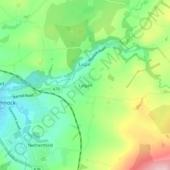
Name: Logan topographic map, elevation, terrain.

Location: Logan, East Ayrshire, Scotland, KA18 3HB, United Kingdom (55.43810 -4.25224 55.47810 -4.21224)

Average elevation: 604 ft

Minimum elevation: 367 ft

Maximum elevation: 1,076 ft

Other topographic maps

Click on a map to view its topography, its elevation and its terrain.

Glenbuck Loch

United Kingdom > Scotland > East Ayrshire

Average elevation: 1,073 ft

River Doon

United Kingdom > Scotland > East Ayrshire > Dalrymple

Average elevation: 551 ft

River Ayr

United Kingdom > Scotland > East Ayrshire

Average elevation: 689 ft

Braid Wood

United Kingdom > Scotland > East Ayrshire

Average elevation: 374 ft

Loch Doon

United Kingdom > Scotland > East Ayrshire

Average elevation: 955 ft

Gear up for your next adventure:

🔌USB Car Charger - Car charger for on‑the‑go power needs
📷Action Cameras - Rugged cameras to document your journeys across rugged terrain
🎒Trekking Poles - Sturdy poles for balance and stability on rough terrain
📷Action Camera - Capture your outdoor adventures in HD
🛡️Bear Spray Outdoor - Protection in bear country hikes

As an Amazon Associate, this site earns from qualifying purchases at no extra cost to you.