Geolocate

Loch Doon topographic map

Click on the map to display elevation.

About this map

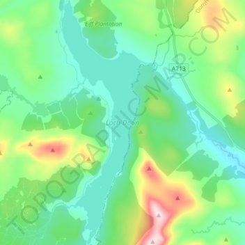
Name: Loch Doon topographic map, elevation, terrain.

Location: Loch Doon, East Ayrshire, Scotland, United Kingdom (55.20488 -4.40081 55.28572 -4.35028)

Average elevation: 955 ft

Minimum elevation: 600 ft

Maximum elevation: 2,034 ft

Other topographic maps

Click on a map to view its topography, its elevation and its terrain.

Glenbuck Loch

United Kingdom > Scotland > East Ayrshire

Average elevation: 1,073 ft

Stewarton

United Kingdom > Scotland > East Ayrshire

Average elevation: 387 ft

Kilmarnock

United Kingdom > Scotland > East Ayrshire

Average elevation: 184 ft

Darvel

United Kingdom > Scotland > East Ayrshire

Average elevation: 702 ft

Knockentiber

United Kingdom > Scotland > East Ayrshire

Average elevation: 144 ft

New Cumnock

United Kingdom > Scotland > East Ayrshire

Average elevation: 902 ft

Waterside

United Kingdom > Scotland > East Ayrshire

Average elevation: 551 ft

Braid Wood

United Kingdom > Scotland > East Ayrshire

Average elevation: 374 ft

Sinclairston

United Kingdom > Scotland > East Ayrshire

Average elevation: 554 ft

Hurlford

United Kingdom > Scotland > East Ayrshire

Average elevation: 161 ft

Cumnock

United Kingdom > Scotland > East Ayrshire

Average elevation: 614 ft

Galston

United Kingdom > Scotland > East Ayrshire

Average elevation: 413 ft

Newmilns

United Kingdom > Scotland > East Ayrshire

Average elevation: 597 ft

Moscow

United Kingdom > Scotland > East Ayrshire

Average elevation: 436 ft

Hollybush

United Kingdom > Scotland > East Ayrshire

Average elevation: 423 ft

Bellsbank

United Kingdom > Scotland > East Ayrshire

Average elevation: 748 ft

Fenwick

United Kingdom > Scotland > East Ayrshire

Average elevation: 466 ft

Stair

United Kingdom > Scotland > East Ayrshire

Average elevation: 266 ft

Auchinleck

United Kingdom > Scotland > East Ayrshire

Average elevation: 482 ft

Crosshands

United Kingdom > Scotland > East Ayrshire

Average elevation: 400 ft

Lugar

United Kingdom > Scotland > East Ayrshire

Average elevation: 597 ft

Catrine

United Kingdom > Scotland > East Ayrshire

Average elevation: 456 ft

Patna

United Kingdom > Scotland > East Ayrshire

Average elevation: 686 ft

Coalhall

United Kingdom > Scotland > East Ayrshire

Average elevation: 341 ft

Dalmellington

United Kingdom > Scotland > East Ayrshire

Average elevation: 935 ft

Mauchline

United Kingdom > Scotland > East Ayrshire

Average elevation: 410 ft

Dalrymple

United Kingdom > Scotland > East Ayrshire

Average elevation: 253 ft

Cumnock

United Kingdom > Scotland > East Ayrshire

Average elevation: 614 ft

Muirkirk

United Kingdom > Scotland > East Ayrshire

Average elevation: 856 ft

Dunlop

United Kingdom > Scotland > East Ayrshire

Average elevation: 433 ft

Logan

United Kingdom > Scotland > East Ayrshire

Average elevation: 604 ft

Lugton

United Kingdom > Scotland > East Ayrshire

Average elevation: 472 ft

Cairnhill

United Kingdom > Scotland > East Ayrshire > Galston

Average elevation: 633 ft

Gatehead

United Kingdom > Scotland > East Ayrshire

Average elevation: 105 ft

Ochiltree

United Kingdom > Scotland > East Ayrshire

Average elevation: 410 ft

Burnton

United Kingdom > Scotland > East Ayrshire > Dalmellington

Average elevation: 814 ft

Kilmarnock

United Kingdom > Scotland > East Ayrshire

Average elevation: 184 ft

Gear up for your next adventure:

🪑Ultralight Camp Chairs - Portable seating for resting after a long day of mapping
🌲Outdoor Survival Books - Best books on survival skills
🥤Water Filter Bottle - All‑in‑one filter bottle for safe hydration
🏕️Family Camping Gear - Essentials for group camping trips
🌧️Backpack Rain Cover - Keep gear dry in wet weather

As an Amazon Associate, this site earns from qualifying purchases at no extra cost to you.