
Upper Saucon topographic map
Click on the map to display elevation.
Upper Saucon
According to the United States Census Bureau, the township has a total area of 24.6 square miles (63.7 km2), of which 24.5 square miles (63.4 km2) are land and 0.2 square miles (0.4 km2), or 0.59%, are water. Its boundary with Salisbury Township is located on South Mountain. Elevations range from 340 feet (100 m) in Spring Valley to 1,042 feet (318 m) at Bauer Rock atop South Mountain in Big Rock County Park. Upper Saucon is in the Delaware River watershed and is drained by Saucon Creek into the Lehigh River, except for a very small area in the extreme south just southwest of Locust Valley, which is drained by Unami Creek into Perkiomen Creek and the Schuylkill River.
About this map
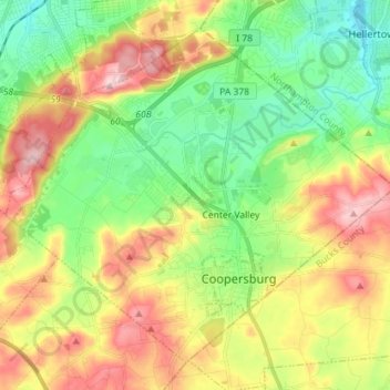
Name: Upper Saucon topographic map, elevation, terrain.
Location: Upper Saucon, Lehigh County, Pennsylvania, United States (40.48798 -75.47584 40.58115 -75.33305)
Average elevation: 574 ft
Minimum elevation: 253 ft
Maximum elevation: 1,037 ft
Lehigh County trails, hiking, mountain biking, running and outdoor activities
Other topographic maps
Click on a map to view its topography, its elevation and its terrain.