
Center Valley topographic map
Click on the map to display elevation.
About this map
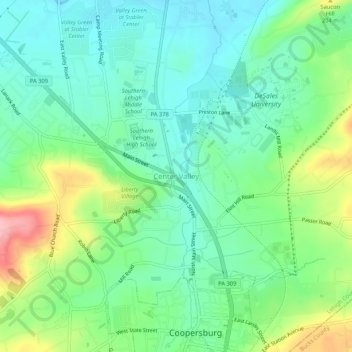
Name: Center Valley topographic map, elevation, terrain.
Average elevation: 499 ft
Minimum elevation: 354 ft
Maximum elevation: 827 ft
Lehigh County trails, hiking, mountain biking, running and outdoor activities
Other topographic maps
Click on a map to view its topography, its elevation and its terrain.
Upper Saucon
United States > Pennsylvania > Lehigh County > Upper Saucon
According to the United States Census Bureau, the township has a total area of 24.6 square miles (63.7 km2), of which 24.5 square miles (63.4 km2) are land and 0.2 square miles (0.4 km2), or 0.59%, are water. Its boundary with Salisbury Township is located on South Mountain. Elevations range from 340 feet (100…
Average elevation: 574 ft