
Make a donation
Gear up for your next adventure:
As an Amazon Associate, this site earns from qualifying purchases at no extra cost to you.
Romette topographic map
Click on the map to display elevation.
Make a donation
Gear up for your next adventure:
As an Amazon Associate, this site earns from qualifying purchases at no extra cost to you.
About this map
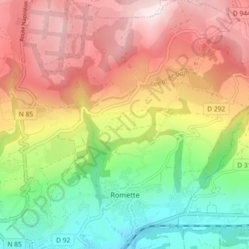
Name: Romette topographic map, elevation, terrain.
Average elevation: 3,471 ft
Minimum elevation: 2,510 ft
Maximum elevation: 4,472 ft
Make a donation
Gear up for your next adventure:
As an Amazon Associate, this site earns from qualifying purchases at no extra cost to you.
Other topographic maps
Click on a map to view its topography, its elevation and its terrain.
Domaine de Charance
France > Provence-Alpes-Côte d'Azur > Hautes-Alpes > Gap > Domaine de Charance
Average elevation: 3,753 ft
Les Vigneaux
France > Provence-Alpes-Côte d'Azur > Hautes-Alpes > Gap > Romette
Average elevation: 3,048 ft
Make a donation
Gear up for your next adventure:
As an Amazon Associate, this site earns from qualifying purchases at no extra cost to you.
Sainte-Marguerite
France > Provence-Alpes-Côte d'Azur > Hautes-Alpes > Gap
Average elevation: 2,562 ft
Make a donation
Gear up for your next adventure:
As an Amazon Associate, this site earns from qualifying purchases at no extra cost to you.
Make a donation
Gear up for your next adventure:
As an Amazon Associate, this site earns from qualifying purchases at no extra cost to you.
Col de Gleize
France > Provence-Alpes-Côte d'Azur > Hautes-Alpes > Gap
Le col de Gleize, à 1 691 mètres d'altitude, est situé dans le département des Hautes-Alpes, sur la commune de Gap, proche du col Bayard.
Average elevation: 5,456 ft
Z.A. Les Fauvins
France > Provence-Alpes-Côte d'Azur > Hautes-Alpes > Gap > Z.A. Les Fauvins
Average elevation: 2,690 ft
Domaine de Charance
France > Provence-Alpes-Côte d'Azur > Hautes-Alpes > Gap
Average elevation: 3,724 ft
Make a donation
Gear up for your next adventure:
As an Amazon Associate, this site earns from qualifying purchases at no extra cost to you.
Les Allouviers
France > Provence-Alpes-Côte d'Azur > Hautes-Alpes > Gap > Romette
Average elevation: 3,140 ft
Domaine de Charance
France > Provence-Alpes-Côte d'Azur > Hautes-Alpes > Gap
Average elevation: 3,724 ft
Make a donation
Gear up for your next adventure:
As an Amazon Associate, this site earns from qualifying purchases at no extra cost to you.