
Make a donation
Gear up for your next adventure:
As an Amazon Associate, this site earns from qualifying purchases at no extra cost to you.
Lareton topographic map
Click on the map to display elevation.
Make a donation
Gear up for your next adventure:
As an Amazon Associate, this site earns from qualifying purchases at no extra cost to you.
About this map
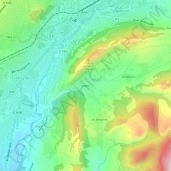
Name: Lareton topographic map, elevation, terrain.
Average elevation: 2,694 ft
Minimum elevation: 2,234 ft
Maximum elevation: 3,658 ft
Make a donation
Gear up for your next adventure:
As an Amazon Associate, this site earns from qualifying purchases at no extra cost to you.
Other topographic maps
Click on a map to view its topography, its elevation and its terrain.
Domaine de Charance
France > Provence-Alpes-Côte d'Azur > Hautes-Alpes > Gap
Average elevation: 3,724 ft
Domaine de Charance
France > Provence-Alpes-Côte d'Azur > Hautes-Alpes > Gap
Average elevation: 3,724 ft
Make a donation
Gear up for your next adventure:
As an Amazon Associate, this site earns from qualifying purchases at no extra cost to you.